Gyratory plans for Nuneaton’s ring road
Just a quick thing...
I have chosen not to use adverts, pop-ups, mailing lists, or mandatory subscriptions, but it means there is an ongoing cost for me in researching and writing content, and generally advocating for active travel - time spent not working! If you can throw a few pounds my way to help out, your support is gratefully received! Thank you!

In a recent video, I took a casual look at the plans for a new gyratory on Nuneaton’s ring road – part of the Major Road Network through the town – and how it fairs for active travel. Since then, I’ve taken a closer look and submitted comments to the County Council that, while critical of a scheme that misses the mark for walking, wheeling, and cycling, also offers suggestions for improvements.
Changes to this part of the road network have been in planning for many years – I first referenced it here back in 2019, and took a look at preliminary plans in 2020 – with feedback frequently given that while the objective may be to tackle congestion and improve motor throughput, this important area must properly serve active travel through high quality, cohesive infrastructure. Congestion cannot be solved by simply expanding capacity and changing the nature of the roads. This is unsustainable and will either shift the problem to other parts of the network, or any short-term benefit will be quickly lost as capacity induces more driving (induced demand). Providing viable travel alternatives in order to reduce the number of vehicles and trips made by car is a key part of a congestion management strategy.
Since then, and long before this latest plan was released, the County Council has published a new Local Transport Plan which puts walking, wheeling, and cycling at the top of the transport hierarchy, and later its Local Cycling and Walking Infrastructure Plans (LCWIPs); and the Department for Transport issued updated national design guidance for cycling (LTN 1/20). All of this should suggest that road redesigns ought to consider active travel as a core and fundamental element. Yet, while this new design does feature some consideration for active travel, ultimately it remains motor-normative with those travelling outside of a car having to use space that is compromised and squeezed to the sides. There is no compromise for driving.
A brief overview of the plans


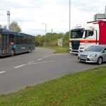
The latest design for the new road junction would see the removal of a building (Empire Gym) and small car park. Earlier proposals to remove a second building currently occupied by Dunelm have been dropped although its car park would be changed with a significant reduction in capacity. Where through traffic currently passes the railway station on a two-lane, one-way section of road, this would be diverted down to the new roundabout where it is planned that Newtown Road, Leicester Road, and Vicarage Street will meet. This will result in quieter roads passing the station.
A bus gate would limit motor traffic access to the roads passing the station (Regent Street and Bond Street), stopping most drivers from using the section as a through route to bypass the new roundabout. Buses would be able to approach much closer to the station than at present.
Cycling features a new 3m bidirectional protected cycleway on Newtown Road (east-west) and some infrastructure would also be provided between Bond Street and Vicarage Street (north-south). However, in the case of the latter, this is significantly compromised through frequent changes in standards and varying widths (under 2.5m effective width at one point). In the case of the former, it’s very close to the main carriageway, is not clear how it connects to Newtown Road at the western end, and merges down into shared space at its eastern end. We also having issues with a large number of road crossing points.
Perhaps most importantly, the scheme makes no changes to the only viable bridge over the mainline railway, leaving cyclists at risk by cycling on a dangerous, busy carriageway on a painted lane cycleway, or in conflict with pedestrians on a narrow footpath with ambiguous shared use status but which is far too narrow for the purpose.
In the following sections, I’ll dive into various parts of the plans and look at the issues for active travel and make suggestions for improvements. If you don’t want to read all of this, I’d at least draw particular attention to the comments on Leicester Road Bridge where this is perhaps the biggest failing of all. It presents as a network gap, limits access to the railway station, and most importantly leaves cyclists at risk of harm on an important route to nearby schools, colleges, and other facilities. It could therefore be argued that it would be negligent on the County Council’s part to build this design without improvements.
Of course, you can also refer back to the video narration from last month which covers off most of these points.
Diving into the plans in more detail
All of the comments below have been fed-back to Warwickshire County Council during the consultation phase, almost exactly as presented here. Whether these plans are ultimately what Warwickshire intends to move forward with, or whether we’ll see more years of revision remains to be seen.
Warwickshire has since acknowledged receipt of this feedback and confirmed it will be logged with the application and shared with the case officer.
Bond Street and Regent Street spur passing the station
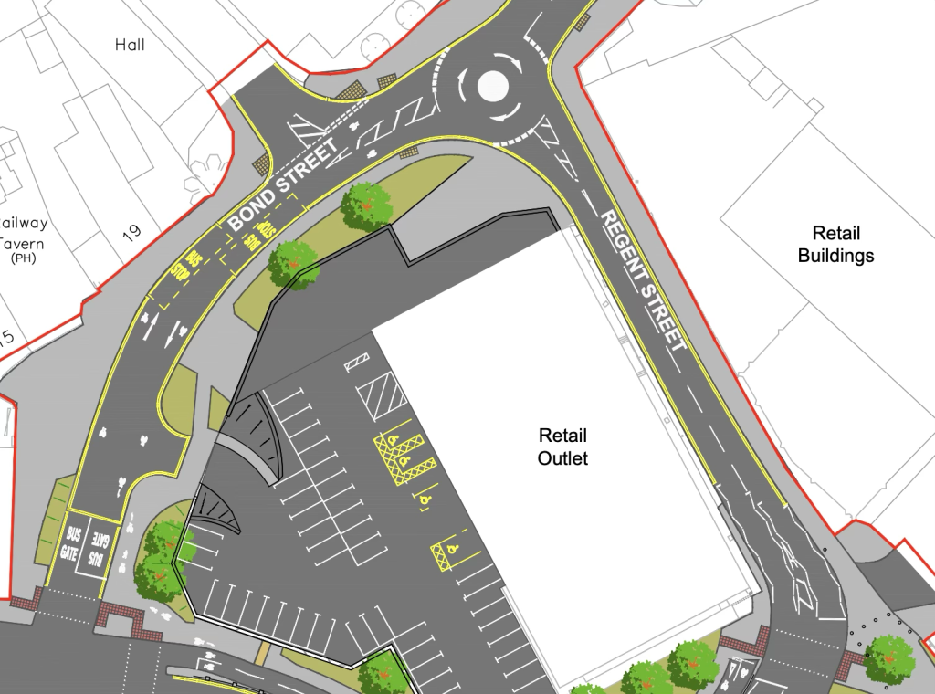
The proposal suggests downgrading these roads from their current status as part of the Major Road Network, to becoming access roads for the station, the retail units, and the private side road, with bus access also provided via a bus gate. As such, general motor traffic will not be able to use this section as a through route. Initially, this is a positive improvement which should see much less traffic near the station.
For cycling provision, the plan shows a small section of shared use path at the bus gate end, where riders are then routed on to the Bond Street carriageway. Thus any person cycling to access the station or other premises along this area is forced to share road space with buses, delivery vehicles, taxis, and private cars – albeit significantly fewer than today. However, when considering the attractiveness and safety of cycling for all ages and abilities, enabling multi-modal transport (cycling+rail), and modal shift, this provision is not acceptable.
Separated cycling provision should be provided into the station grounds, ideally direct to high quality secure cycle parking infrastructure, to minimise conflict with other road users (pedestrians, drivers), and to provide a safe, comfortable, and attractive connection where a family would feel confident allowing young children to ride even independently.
To facilitate this, it would appear viable to change this layout to a single lane, one-way road for all motor traffic, on an anti-clockwise basis – i.e., all vehicles enter the loop at the gyratory roundabout, and leave at the signalled junction with Newtown Road (where bus gates are indicated at present which would be removed under this suggestion). This would allow space for a separated bidirectional cycleway to proceed around the loop, to join the planned bidirectional cycleway at both ends. Given there’s no need for motor vehicles to use the road apart from access, a single lane for motor traffic would presumably be sufficient and would not be detrimental to drivers.
Such a bidirectional cycleway leaving Bond Street should then connect to Vicarage Street via a parallel crossing and continuation of separation into the already indicated cycleway passing Back Street
Indicated bidirectional cycleway on Newtown Road to Regent Street
It is good to see separated cycle provision featured as part of this design. However, the provision is very limited and has a few issues that should be addressed.
There is no clear indication of how the protected cycleway on Newtown Road joins the ring road for cyclists heading in a west bound direction (i.e., away from the gyratory). The protected space appears to end but with no means for riders to easily and safely transition from the north side of the carriageway to the south side. This needs to be clearly and safely designed if indeed the protected route does not continue over the river and towards the retail park and bus station (which would be preferable).
For the provision routing on the northern edge of the new roundabout between Bond Street and Regent Street, separation from the main carriageway appears to be very slim, perhaps featuring a narrow strip of kerbing, guardrails, and maybe bollards. This therefore appears to reduce the effective width of the cycleway below three metres which may impact westbound riders, forcing them closer to the central line of the cycleway to avoid handlebars impacting on furniture, or (where furniture is low) overhanging close to oncoming motor vehicles.
This road is also likely to be very busy especially at peak times and thus quite uncomfortable when riding against the flow of motor vehicles. This may be especially true when approaching large vehicles including HGVs, and at night and in bad weather where headlamps, spray, and surface water can impact visibility. Drivers may also be startled by oncoming cycle lights on what they might perceive to be the wrong side of the road.
Given the swooping nature of the road and cycleway that requires changes in direction, the discomfort and potential confusion caused by such a limited buffer between drivers and cyclists may be exacerbated compared to a straight road where no direction changes are made. There would appear to be a potential risk to cyclists should a driver collide with the guardrail providing the separation, particularly if this were to happen at peak time with many riders using the cycle infrastructure. The lack of a buffer could mean a collision may still encroach on cycle space.
At the eastern end of the cycleway, the route merges into shared use space and makes use of a toucan crossing over Regent Street. This puts all active travel users into conflict with each other. Turning angles appear to be tight, particularly on west bound journeys, and may be further restricted by street furniture (e.g., poles for traffic signals). Thus this may not be accessible particularly at busy times. Infrastructure must be designed to comfortably accommodate the Cycle Design Vehicle.
To address these points, a greater buffer needs to be provided between the cycleway and the main carriageway. This may be achieved by removing three or four south-most car park spaces from the retail unit (Dunelm), and aligning the cycleway through that space, alongside the retail unit under the marked trees, and then approaching the crossing point which should become a parallel crossing. The route can also then connect with my proposed continuation of a bidirectional cycleway along Regent Street and Bond Street (see above). Green space created between the cycleway and roundabout can be used for additional tree planting, improving aesthetics, biodiversity, and providing valuable shade in summer months.
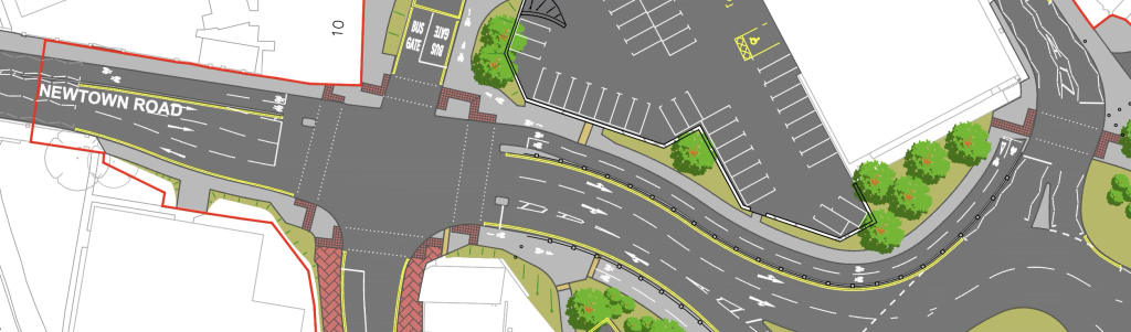
Cycle route from Newtown Road passing Back Street and joining Vicarage Street
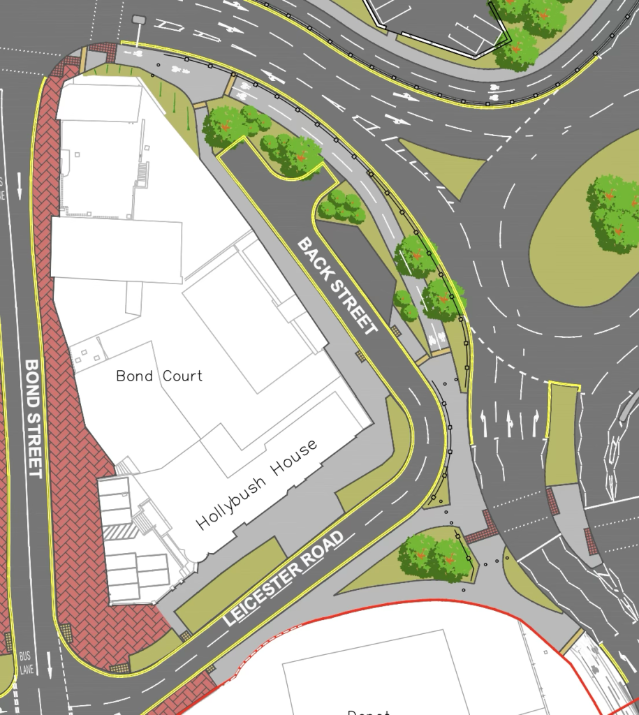
The current indication for this route (described here from the north and heading south) starts with shared use space. It then changes to a short length of separated provision, reverts back to shared use space (where two-stage crossing points of Vicarage Street are located), before again changing to separated provision on Vicarage Street itself.
Shared use space is strongly discouraged in current design guidance for this type of environment, where it should be planned and expected to see an increase in walking, wheeling, and cycling numbers. Shared use is uncomfortable for all users, perceived as dangerous by some pedestrians, and may pose an accessibility issue (for example, for visually impaired pedestrians.) The use of this standard imposes a limit on the growth of active travel where, once numbers become too high, it will not be perceived as comfortable or safe and thus other transport options will be deemed a better choice (i.e., driving, public transport).
The provision of bollards/guardrail alongside the shared space as it passes the corner of Back Street/Leicester Road further narrows the effective width of the space for walking, wheeling, and cycling to what would appear to be under 2.5m of gross width; less for effective width. The provision of crossing points on Vicarage Street just south of here also present as points of conflict with people waiting to cross the road.
Shared use sections should be removed. Where there genuinely is no alternative – and this seems very unlikely, as noted below – the length of space should be minimised while maximising the available width. But full separation should be possible for the most part.
The removal of shared space on the section to the north by Newtown Road would be achievable with the provision of separated cycling around Bond Street and Regent Street as detailed above.
The removal of the mid-section shared space can be achieved by either:
- Pushing motor lanes to the east, thus reducing the reservation between northbound and eastbound lanes;
- Ensuring each road lane is sized to the absolute minimum possible width, noting that at present lanes appear to be about 3.9m wide which is perhaps excessive;
- Where lanes must be so wide, reducing the number of approach lanes to two (left; straight and right – as lanes are marked on approach to the toucan crossings);
- A combination of any/all of the above.
In the case of point 1, this would impact of the provision of the two crossing points. However, these crossings are slow, uncomfortable, potentially inaccessible, and for all users undesirable – including drivers who are presented with traffic signals to enable the crossings. This matter is addressed in the following section, by altering the interaction of active travel with the gyratory to permit unhindered crossings.
Navigating the gyratory to connect Vicarage Street with Leicester Road Bridge
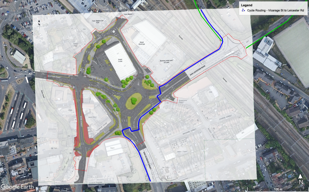
As planned, to cycle north on Vicarage Street and then join Leicester Road Bridge on an eastbound heading, such journeys require the use of four controlled crossing points in shared use spaces.
At points where people must wait to cross the road, this introduces conflict with users wanting to pass the crossing location. Particularly when between carriageways, turning angles may be tight and limited space may become congested, again putting people into conflict. Such crossings may be considered inaccessible, would not accommodate multiple cycles (particularly larger cycles or with trailers etc.), and can also take a long time to navigate. All of these elements serve as detriments to enabling active travel and modal shift and will limit growth in walking, wheeling, and cycling.
This can be improved by installing the gyratory on a lower level and providing ground-level bridged crossings to bring active travel into the centre of the gyratory and out again. Such crossings can maintain separation between pedestrians and cyclists while connecting with the existing planned cycleway and my suggested Regent Street/Bond Street cycleway for the provision of a continuous, cohesive, attractive, and safe network.
While such a design would undoubtedly be more costly to install, given the area is to be under significant redevelopment anyway with the removal of a building and car park to facilitate it, the additional cost is worthwhile. It will provide benefits to all road users – as noted, pedestrians and cyclists can navigate the gyratory unhindered on comfortable turns; drivers would not be presented with traffic signals for the crossings thus improving their experience of using the junction and improving throughput of motor vehicles, regardless of how the numbers of people choosing active travel change over time – and it has the potential for better placemaking.
By removing the need for the crossing points, the central reservation space between the northbound and southbound carriageways of Vicarage Street can be reduced, This enables more space for active travel to be provided on the western side, ideally to continue separated cycling through space that is currently indicated as shared.
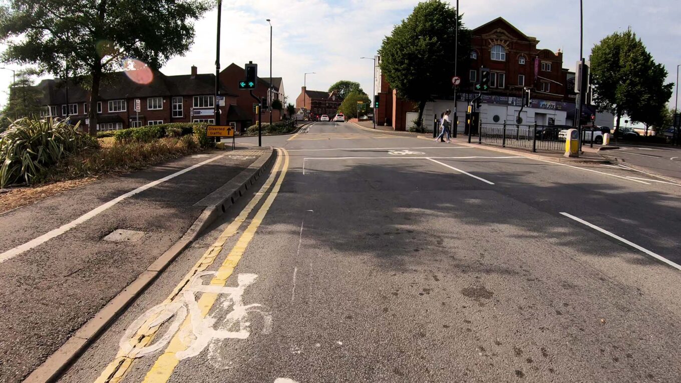
Leicester Road bridge and Trent Road
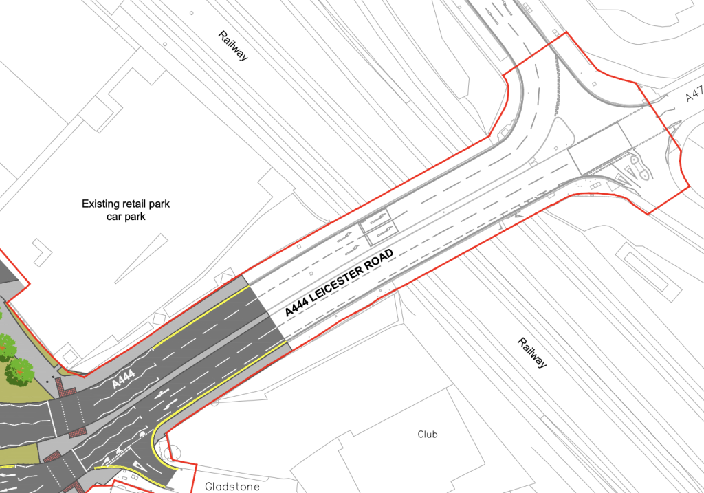
While the scope of the scheme appears to encompass all of Leicester Road bridge, there are no indications that any changes are being made to the layout of the road to improve active travel here.
A lack of improvements is not acceptable. The bridge forms the only viable direct connection over the mainline railway. It is an essential link for all road users but is, at present and as shown in this scheme, almost entirely dominated by driving with everyone else utterly squeezed to the sides. This actively puts cyclists in harms way, especially when they are required or may deem it necessary to choose to use the main carriageway (e.g., on a south west heading in the painted lane cycleway).
As things stand, two narrow footpaths are provided for people walking and wheeling. For cycling, the north side path appears from road signage to be classed as shared space (although this classification is ambiguous) despite the path being too narrow for that use – under 3m gross width; far less effective width given the bridge wall, street furniture, and the proximity of the carriageway. The south side features just a narrow painted lane for cycling which is dangerous and intimidating on a busy road that accommodates heavy vehicles. This does nothing to welcome casual, everyday transport cycling for all ages. Instead, it’s a significant deterrent.
This bridge must be improved to facilitate better provision for all active travel users. Whilst appreciating there is a hard limit on space here, a means for providing bidirectional separated cycling simply has to be found one way or another. Failure to do so would demonstrate negligence on the part of the County Council towards the safety of anyone who is not driving.
On the assumption that a new accessible bridge dedicated to active travel is not feasible on cost and space considerations, two options present themselves – either widen the bridge to provide the space necessary for a good quality, safe cycling link suitable for all users and cycle types (presumably also cost prohibitive), or road space must be reallocated. If space cannot be found by narrowing lanes and reducing the central reservation width, a general carriageway lane must be removed and handed over to active travel, leading to a combined maximum of three lanes for driving.
On the basis of such space reallocation, it would appear reasonable to provide one single east bound lane for driving (where two lanes are perhaps viable again after the bridge on the north eastern side as the road turns north) and maintaining two west bound lanes. The pavement on both sides of the bridge can then be widened to provide more space for walking and wheeling, with a bidirectional cycleway provided on the north side of the bridge. This would then be able to tie in to the gyratory avoiding the need to use shared space.
Again, it is entirely inappropriate to leave this bridge in its current state. To do so actively harms attempts at providing modal shift and maintains a dangerous environment for cycling. It is an important route to and from nearby schools and colleges. The bridge presents as a network gap between the gyratory scheme and the proposed cycle routes on the A47 Hinckley Road/Long Shoot and Weddington Road. Even if all paths were to be classed as shared, space is too restricted for large numbers of pedestrians and cyclists to mix together and thus would not meet design standards – given the proximity of Etone College (the nearest high school), these paths already get very busy at peak times.
Just within the boundary of the scheme to the north east, Trent Road is shown with no changes. This needs to be upgraded to provide a continuous, level path over the junction to communicate pedestrian priority over drivers entering or leaving Trent Road. While this crossing exists as shared space, cycling should also be accommodated on a continuous path. Drivers would thus be required to cross a raised platform. This will aid the connection to Etone College.
Regent Street (south)
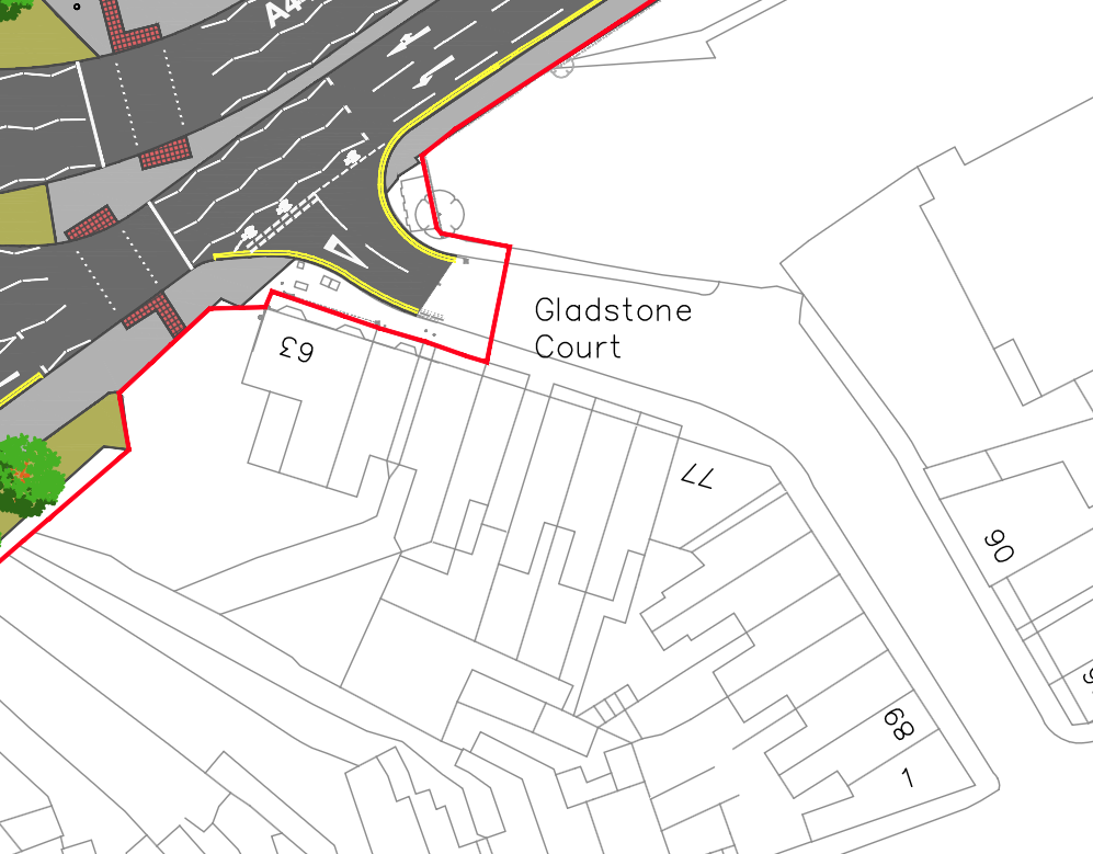
This refers to access to the south arm of Regent Street from Leicester Road, marked as Gladstone Court on the plans.
Regent Street (south) has the potential to serve as a back road ‘quiet way’ for cycling for those who wish to bypass the ring-road when travelling to/from areas to the south of the town. As such, this junction should be closed to motor vehicles where access to properties is maintained via Wheat Street.
There is no clear need or benefit to maintaining this road as a through connection where it may currently serve as a ‘rat run’ for drivers attempting to avoid traffic at the gyratory.
Maps and designs produced by Warwickshire County Council, Crown Copyright 2024.
Have you found this content interesting or useful? If so, and if you are able to, any contributions are greatly appreciated! Thank you! Oh, and do please share with others!