

Nuneaton’s shortest shared use path?
Just a quick thing...
I have chosen not to use adverts, pop-ups, mailing lists, or mandatory subscriptions, but it means there is an ongoing cost for me in researching and writing content, and generally advocating for active travel - time spent not working! If you can throw a few pounds my way to help out, your support is gratefully received! Thank you!

When it comes to shared use infrastructure, how short is too short? Perhaps when it’s only a few metres, flanked on either side by a regular footpath (i.e., not designated for cycling), and where the path on the opposite side has a proper and useful (if poor considering modern standards) shared use route.
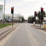
This is the situation on St George’s Way in Nuneaton, where the new installation has been fitted as part of the Bermuda Connection Project. In the photo of the short section, the start and end are clearly marked on separate poles spaced with just a few metres between them. On the pole showing the roundal that marks the beginning of the shared space, the reverse outline of two signs can be seen – the same two signs that mark the end of route and instruct cyclists to dismount that are visible on this angle (confirmed from a grainy cycle camera image). This is definitely just a stub of shared use path.
The highly controversial, expensive, and over-running road scheme opened up a through route for motor traffic, making use of a bridge over the A444 – a bridge that was formerly closed to motor vehicles but useable as an important pedestrian and cycling link crossing the busy main thoroughfare to town. Part of the project included the creation of a shared use path running from the existing main roundabout, along St George’s Way, and over the bridge before ending where riders are required to rejoin the carriageway.

That shared use path exists on the eastern side of St George’s Way, but the reason for the very short on the western side is not clear. The only possible reason I can see is that it allows riders who might be on the carriageway heading northbound, to leave the carriageway with a safe place to cross over to the main shared use path. This seems to be a stretch in reasoning though – a cyclist who has chosen the road this far would presumably be happy to continue on the road over the bridge.
Beyond that mystery, Warwickshire County Council have also used incorrect signage. Riders should never be asked to dismount. Instead, they should be asked to rejoin the carriageway, or a proper crossing should be provided to connect with the opposite path. The same signage has been used on the other side of the bridge.

Have you found this content interesting or useful? If so, and if you are able to, any contributions are greatly appreciated! Thank you! Oh, and do please share with others!


I think I may know what this is about. Before the shared use path was installed St Georges Way had two way painted line cycle paths either side of the road. This tiny bit of shared path allowed someone at the end of the cycle route heading towards the bridge to come off the road, then cross the road to join the shared use path heads towards Hill Top (with a very narrow K-Frame barrier to contend with). It was never signposted and it was often easier just to come out of the cycle lane and turn right. With the addition of the shared use path and removal of the cycle route the only reason why someone would do this is if they were cycling on the road, wanted to use the shared path to Hill Top and wasn’t confident negotiating the right turn which seems very unlikely. I notice they also retained the “END OF ROUTE” sign:- https://www.cycling-embassy.org.uk/dictionary/end-of-route
Thanks Dan. That’s along the lines of my speculation then. It seems a bit odd to include it in this form though; I’d say the purpose isn’t clear. Like you, I’d speculate that someone who was happy to be on the road instead of the shared use path for the duration of St. Georges Way (or part of it if coming from one of the business sites) would be confident enough to make a right turn. It also looks *extremely* tight for turning around given the limited space and that narrow dropped kerb.
There is a problem along St George’s Way where it’s not easy to access the shared use path from the side roads, so I can perhaps see that would be why someone might be in the road. Failing improvements to that situation, it would be better I think to have a longer section of shared use on the western side to facilitate a comfortable pick-up, with a formal crossing to access the older path to Middlemarch Road.
And yes, that barrier to Middlemarch Road is a long-standing problem in its own right!
My speculation would be that the planners actually want the pavement to be used as a shared use path. That’s why they don’t say “rejoin carriageway”. But legally, the path doesn’t meet the minimum requirements for a shared use paths, so they (have to) put up the cyclists dismount signs. Technically, cyclists are not allowed to cycle on the pavement, but as long as nothing happens it is accepted. If something happens everyone can blame the cyclist for ignore the dismount sign.